Share This Article
I am usually not a very tech girl, but the weather in the Azores islands is SO unpredictable and ever changing, that when I moved here I had to quickly learn how to check the weather parameters. So for me, the best apps to use in the Azores islands are definitely WindGURU (for clouds and wind information) and SpotAzores (to check in real time how the weather is in particular spots).
Over time, I discovered some other incredibly useful apps that I am now sharing with you. I hope you make good use of them!
These Apps will SAVE YOU in the Azores islands
WindGURU
WindGURU is the best app to use in the Azores islands unless you intend to spend your time there living under a rock. And even so you will probably need to use WindGURU because there can come one of those downpours and your ass is dragged to the bottom of the sea. So, WindGURU it is 😛
WindGURU is an app specialized in forecasting weather, initially created with windsurfers and kitesurfers in mind, but that is used pretty much by everyone in the Azores islands to decide when to go hiking / go fishing / go down a volcanic crater / go up a mountain etc etc.
It can be daunting to try to understand windGURU at first, but it is really not that complicated.
I used it mostly to decide where and when to go hiking in the Azores islands, and these are the parameters that you need to pay most attention to:
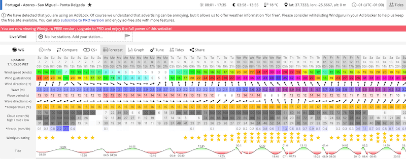
- Cloud Cover (%) High / Mid / Low: this basically tells you if it is worth it to go hiking in high places, like climbing the Pico mountain, the tallest point in Portugal. The results are displayed as a percentage and at three altitudes (high, medium and low). The higher the number, the more covered the terrain is at that altitude, and the cell where the result is displayed is painted in a darker gray.
How to use WindGURU in the Azores?
If you want to do a trail in the middle of the islands, where the altitude is higher, choose a day when the numbers of Cloud Cover are low and are displayed in white or light gray. If the numbers are high and dark gray, it’s not worth doing a trail in the center of the island because you won’t see ANYTHING. It is better to choose a path by the sea.
- Wind Speed and Wind Direction: these two parameters are also critical when deciding when and where to go hiking in the Azores.
Basically, the stronger the wind the more dangerous it is to go hiking.
Moreover, the direction of the wind is also of the utmost importance.
For instance, if you want to hike to Fajã do Além, which is on the north face of the island of São Jorge, and the wind is blowing south, it means that you will be completely exposed to the wind, which can be dangerous. If the wind blows to the North, you will be protected by the island itself.
I didn’t use to care about any of this stuff (for me every day was a good day to go hiking) but trust me, nature is a tremendous force in the Azores islands and you would be stupid to ignore it.
So for me and every single person I met there, WindGURU is definitely one of the best apps to use in the Azores islands as it can save your ass!
Spot Azores
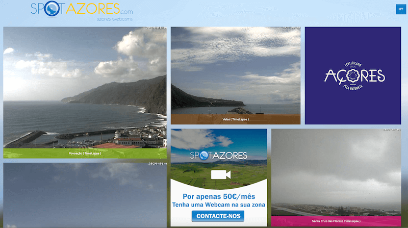
Spot Azores is reeeeeally one of the best apps to use in the Azores islands because it shows, in real time, what the weather is like on each island through webcams located at key points.
Naturally, you have to have a sense of where those cameras are placed, otherwise you won’t be able to use that information.
Some are quite obvious, of course. For example, if you want to go down to the Caldeira Volcano in the Faial island, just look at the “Caldeira” camera on the island of Faial, which you can immediately see if the top is uncovered or covered by clouds.
Other areas may not be so obvious because, as you can imagine, there are not cameras at every single point of interest on every single island in the Azores.
Therefore, the ideal is that you use SpotAzores together with Google Maps, to understand which camera is closest to the place you want to visit.
Maps.Me
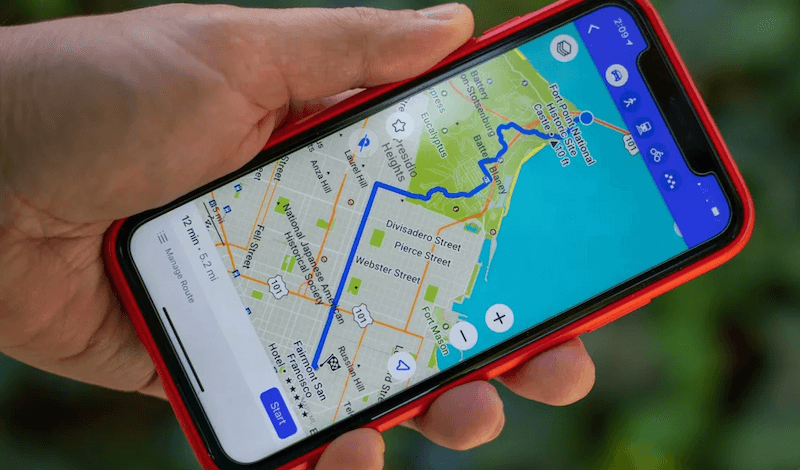
I can’t tell you HOW MANY TIMES Maps.Me saved me when I was a bit lost during my hikes in the Azores islands, especially on the worst hikes in São Miguel. You can read and prepare all you want but you only know what you’re gonna get when you are on the field, and that is when things get complicated. Sometimes the trail is not well marked, or it rained a lot and this caused changes in the terrain, or, or… there were times when I had doubts about how to continue the trail and through Maps.Me I could see where I was and how to proceed.
The right way to use Maps.Me is to load the maps of the countries or regions that you’re going to visit before you leave (or while traveling, in a place with Wi-Fi). Then, you can use them wherever you are even if you don’t have a Wi-Fi connection.
Agenda Açores

If you are interested in getting to know the local culture and participating in events on the islands you are going to visit, I advise you to use the Azores Agenda. It’s not exactly one of the best apps to use in the Azores islands as it’s not an app, it’s a website :P 😛
But nonetheless, it is a good starting point to find temporary exhibitions, markets and local celebrations that will allow you to better understand the life and culture of each island.

